


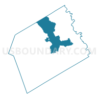
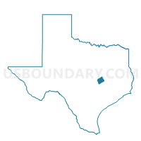
Voting District 0212, Milam County, Texas
About
Outline

Summary
| Unique Area Identifier | 675876 |
| Name | Voting District 0212 |
| County | Milam County |
| State | Texas |
| Area (square miles) | 108.22 |
| Land Area (square miles) | 108.02 |
| Water Area (square miles) | 0.20 |
| % of Land Area | 99.81 |
| % of Water Area | 0.19 |
| Latitude of the Internal Point | 30.87750590 |
| Longtitude of the Internal Point | -96.94816150 |
Maps

Graphs
Select a template below for downloading or customizing gragh for Voting District 0212, Milam County, Texas


Neighbors
Neighoring Voting District (by Name) Neighboring Voting District on the Map
- Voting District 0101, Milam County, TX
- Voting District 0103, Milam County, TX
- Voting District 0210, Milam County, TX
- Voting District 0303, Falls County, TX
- Voting District 0304, Falls County, TX
- Voting District 0310, Bell County, TX
- Voting District 0316, Milam County, TX
- Voting District 0317, Milam County, TX
Top 10 Neighboring County Subdivision (by Population) Neighboring County Subdivision on the Map
- Rockdale CCD, Milam County, TX (8,315)
- Cameron CCD, Milam County, TX (7,028)
- East Bell CCD, Bell County, TX (6,219)
- Rosebud CCD, Falls County, TX (2,765)
- Gause-Milano CCD, Milam County, TX (2,612)
- Buckholts CCD, Milam County, TX (1,261)
- Burlington CCD, Milam County, TX (1,208)
Top 10 Neighboring Place (by Population) Neighboring Place on the Map
Top 10 Neighboring Unified School District (by Population) Neighboring Unified School District on the Map
- Rockdale Independent School District, TX (9,036)
- Cameron Independent School District, TX (8,522)
- Rosebud-Lott Independent School District, TX (4,928)
- Rogers Independent School District, TX (3,901)
- Milano Independent School District, TX (1,743)
- Gause Independent School District, TX (870)
Top 10 Neighboring State Legislative District Lower Chamber (by Population) Neighboring State Legislative District Lower Chamber on the Map
- State House District 20, TX (228,091)
- State House District 55, TX (176,215)
- State House District 57, TX (144,556)
Top 10 Neighboring State Legislative District Upper Chamber (by Population) Neighboring State Legislative District Upper Chamber on the Map
- State Senate District 5, TX (899,155)
- State Senate District 22, TX (789,412)
- State Senate District 24, TX (778,148)
Top 10 Neighboring 111th Congressional District (by Population) Neighboring 111th Congressional District on the Map
Top 10 Neighboring Census Tract (by Population) Neighboring Census Tract on the Map
- Census Tract 201, Bell County, TX (6,219)
- Census Tract 9503, Milam County, TX (3,861)
- Census Tract 9504.02, Milam County, TX (3,736)
- Census Tract 9504.01, Milam County, TX (3,292)
- Census Tract 7, Falls County, TX (2,765)
- Census Tract 9505, Milam County, TX (2,612)
- Census Tract 9501, Milam County, TX (2,469)